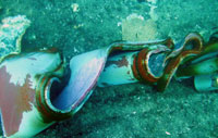
This underwater photo taken on January 17, 2012 at the "Le Scole" rock shows twisted wreckage on the sea floor, left by the cruise liner Costa Concordia after it ran aground in front of the Isola del Giglio harbor. (AFP/Getty Images)
It appears that the question of where and on what the Costa Concordia ran aground is a bit more clear. Wreckage, believed to be from the collision, has been photographed at Le Scole rock. Thanks to Andy Hall at the Maritime Texas blog for pointing it out. See also the Atlantic Monthly’s Inside the Wreck of the Costa Concordia. Yesterday we posted:
There is a 150 foot long rip in the hull on the port side of the ship with a large piece of stone still embedded in the hull. From the position of the damage on side of the hull, it appears that the ship may have scraped along an underwater ledge rather than hitting an underwater pinnacle of rock which would have damaged the bottom of the ship. There are underwater ledges in the vicinity of the small island of Le Scole off the south-eastern of the island of Giglio. This would put the grounding just slightly to the south of the assumed position of the grounding in the AIS plot developed by Lloyds, but the damage would agree with that observed on the hull. Sky News has an animated reconstruction of this scenario.
[iframe: width=”640″ height=”360″ src=”http://video.sky.com/embed/external/16152652″ frameborder=”0″ allowfullscreen]
Le Scole is a popular dive site off the island of Giglio.

I hope Sky News credits John Konrad at gCaptain for this reconstruction.
http://gcaptain.com/gcaptains-john-konrad-narrates-the-final-maneuvers-of-the-costa-concordia-video/?37941
There were several animations out there. I wouldn’t be surprised if the Sky News version might have preceded Konrad’s. Konrad’s version appears to be based on the same data but is much more detailed.