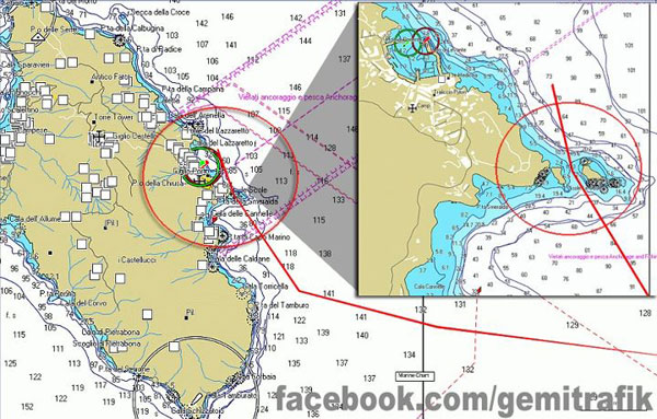
The question being asked by almost everyone is “how could this have happened to a modern cruise ship?” The Costa Concordia was a modern ship, operating in well charted waters, in good weather and calm seas. Obviously, despite a wide range of speculation, no one currently has the answer. What is known is often contradictory or simply mystifying. The captain maintains that the ship hit an uncharted rock and implies that there was nothing wrong with their course. If however AIS plots from various sources are accurate, the ship was steered very close to the island of Giglio and specifically cut through a passage near the popular dive spot, Le Scole, between two large rocks which was suitable only for vessels much smaller than the almost 1,000 foot long cruise ship. (Update: More recent AIS plots are showing a passage to the east of the islands, but still extremely close.)
Costa Concordia: A major navigational error, or what?
Fortunately, the “black box” data recorder has been removed from the ship and taken ashore for analysis. The ship also has two bridge web cams which should record images every few seconds. A web cam in the port of Gigli is also believed to have record the grounding.
The Costa Concordia had the most modern navigational and bridge management systems available. Nevertheless, technology itself can not prevent accidents. When the SS Andrea Doria and the MS Stockholm collided in 1956 off Nantucket, Massachusetts with the loss of 56 lives, both ships were observing each other on radar up until the moment of collision. It was in a real sense a radar-assisted casualty. Technology can never replaced seamanship.

This mornings news report mentioned that the charts didn’t disclose (show) the rock that they hit.
I find that a bit hard to believe if it was big enough to cause that kind of damage.
I don’t think that the captain has much credibility. If the AIS plots are correct, the ship had no business being where it was.
WoW! I can see the rocks on Google Earth. Maybe the capt. should have use that to navigate.