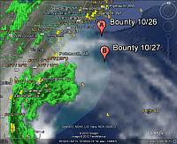
Position of HMS Bounty
Tropical Storm Sandy returned to hurricane strength on Saturday morning as it heads toward the U.S. northeast coast. The US Navy as ordered 24 of the larger ships in southeastern Virginia bases, including the aircraft carrier USS Harry S. Truman, out to sea to avoid the storm. Those ships which cannot leave are taking extra precautions stay secure a their docks. Military installations along the Eastern Seaboard, including Andrews Air Force Base and Langley Air Force Base in Virginia and Naval Submarine Base New London in Connecticut were also prepared to move ships and aircraft if needed.
Cruise ships on the East Coast and Caribbean are shuffling their itineraries Some are tied up securely in port or steaming out to sea to avoid the storm. Holland America’s Eurodam, was forced to dock at a cargo pier in Jacksonville and disembark passengers. Enchantment of the Seas, which left Baltimore October 26 for a five-night Bermuda cruise, will head out to sea in an effort to find calm seas. More than a dozen other ships are delaying or altering their schedules to suit the storm.
The Sunday activities at the annual Sultana Project Downrigging Weekend have been cancelled to allow the participating ships to seek refuge. From the Facebook page for the replica Kalmar Nykel this morning: Underway at 0604 this morning to run home ahead of Sandy. Thanks to the crew who put in a spectacularly big day yesterday, both sailing and downrigging, listened to the revelers all night last night, got up at 0500 to get out of there, and even at this moment are getting ready to send down the fore and main top yards. Winter mooring lines still lie ahead this evening, but it will be great to be home.
The tall ship HMS Bounty, which departed New London CT bound for St. Petersburg, FL on Thursday is now reported to be “250 miles due east of the Chesapeake Bay on a Southwest course at 6.8 knots. The Captain reports that Bounty should be encountering weather from the storm sometime this evening.”

Three storm systems: Look what is brewing out in the north Atlantic:
Java satellite image here, but may take awhile to load, when it does come-up, click the box marked NCEP Fronts http://www.ssd.noaa.gov/goes/east/natl/loop-wv.html