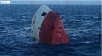
 The passengers on the NorthLink ferry Hrossey, crossing Pentland Firth, off Scotland, saw a grim sight out the ferry windows — the bow of the cement carrier Cemfjord floating vertically in the water. No distress call was received from the ship, which had been carrying 2,000 tonnes of cement and had been sailing from Aalborg in Denmark to Runcorn in Cheshire. Searches were conducted using lifeboats and helicopters but there was no sign of the crew of eight aboard the ship. The coast guard has said that chances of finding survivors is “very slim“.
Four RNLI lifeboats launched in major search after upturned hull found
Thanks to Niall Sinclair and Phil Leon for contributing to this post.

It is strange no emergency call was received. The EPIRB (the emergency radio-beacon) failed, as no signal was received. The Pentland Firth is known for its strong currents, eddies and races.
I agree, since it is duty, according to SOLAS, to carry Emergency Position Indicating Radio Beacons within their emergency life rescue rafts on mercant vessels. And according to newspaper reports, an emergency life rescue raft belonging to the sunken Cemfjord was found on January 5th, 2015, 67 sea miles east from the latest position of the cemfjord. That distance is within Cape Wrath, or at least near Durness.
The newspaper article, which reported about the Cemfjord accident can be read here:
http://www.pressdisplay.com/pressdisplay/de/viewer.aspx (Tagesspiegel (Berlin), No. 22 363, Sunday 5th April 2014, p. 4-5.
In this article another very striking theme was reported, which collides to the know direction of the Gulf stream in the Pentland Firth. The north Atlantic current has a west-east direction, and not, as displayed in a graphic in the mention article, an east-west direction. Source: http://en.wikipedia.org/wiki/North_Atlantic_Current
An emergency life rescue rafts, in the case the crew was able to enter it, should have drifted eastwards, as stated in the article, towards the main land of northern Europe (Scandinavia). If the report of finding an emergency life rescue raft belonging to the Cemfjord, is true, than this raft was found in the North Sea.
The flow direction shown in the graphics of the report “Was geschah mit der Cemfjord” [Tagesspiegel (Berlin), No. 22 363, Sunday 5th April 2014, p. 4-5] shows the tidal race (predominately from east to west), at the presumably time of the accident. The flow direction of the north Atlantic current itself is not changed, and causes a steady west-east flow. Also, circulating water flow around the Orkney islands should be taken in account, caused by the influence of tidal races – north Atlantic current. Tidal races and flow velocities are very high at the point of ship sinking.