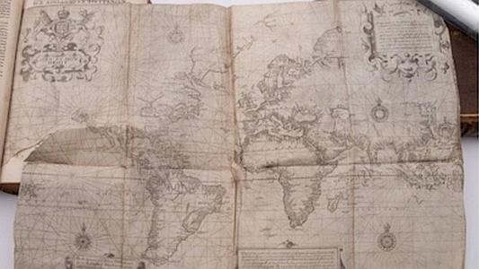
Image: BEARNES, HAMPTON AND LITTLEWOOD
The three-volume The Principall Navigations, Voiages, Traffiques and Discoueries of the English Nation, written by Richard Hakluyt in 1599, and published bound as two books, were only expected to sell for between £3,000 and £5,000. Instead, they sold at an auction for £365,000.
What made the books so valuable was a rare folding 16″ by 18″ (40cms by 45cms) map of the world from 1599-1600 included with the books. Normally when copies are sold, the map is missing.
A spokesman for the auction house in Exeter said: “Unusually, the folding map of the world was present and although in a delicate state, it didn’t deter prospective purchasers.” They said that buyers were interested from “all corners of the globe”.
According to the John Carter Brown Library, the map was one of the first printed world maps using the innovative Mercator projection. It was drawn in 1599 by Edward Wright, an English mathematician. His two-sheet world map was published, unattributed to Wright, in Richard Hakluyt’s Principal Navigations…
The books by Hakluyt had been in the same family for many years and were kept in a private library in Devon.
Thanks to Armchair Seadog for contributing to this post.

All the revered explorers used Chinese charts to take them to their “newly discovered” destination. Columbus, Magellan et al. It would have been like Elon Musk landing on Mars only to find a McDonalds with a working ice cream machine.
A fantastic read (and great hint to the family for your Christmas present,) is “1421: The Year China Discovered The World” by Gavin Menzies. Its subject is the great expedition by the eunuch admirals, (I kid you not,) in ships, giants of their time, their rudders were ten metres high, that split into two fleets being pushed by the trade winds circumnavigating the globe. (Spoiler alert for the flat earth society.) A recently blown down tree in Australia had some of their pottery discovered that had been buried in the roots. It is a historical and factual read with a story better than fiction and a real twist at the end.